
Make a donation
Guadeloupe topographic map
Click on the map to display elevation.
Make a donation
Guadeloupe
The two main islands are Basse-Terre (west) and Grande-Terre (east), which form a butterfly shape as viewed from above, the two 'wings' of which are separated by the Grand Cul-de-Sac Marin, Rivière Salée [fr] and Petit Cul-de-Sac Marin. More than half of Guadeloupe's land surface consists of the 847.8 km2 Basse-Terre. The island is mountainous, containing such peaks as Mount Sans Toucher (4,442 feet; 1,354 metres) and Grande Découverte (4,143 feet; 1,263 metres), culminating in the active volcano La Grande Soufrière, the highest mountain peak in the Lesser Antilles with an elevation of 1,467 metres (4,813 ft). In contrast Grande-Terre is mostly flat, with rocky coasts to the north, irregular hills at the centre, mangrove at the southwest, and white sand beaches sheltered by coral reefs along the southern shore. This is where the main tourist resorts are found.
Make a donation
About this map
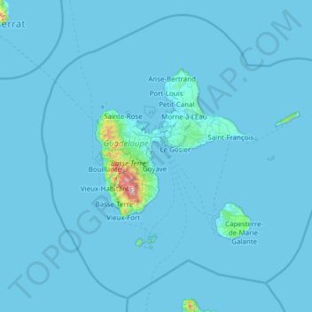
Name: Guadeloupe topographic map, elevation, terrain.
Location: Guadeloupe, France (15.64441 -62.01804 16.71400 -60.79197)
Average elevation: 18 m
Minimum elevation: -1 m
Maximum elevation: 1,428 m
Make a donation
Other topographic maps
Click on a map to view its topography, its elevation and its terrain.
Val Thorens
France > Auvergne-Rhône-Alpes > Savoy
Val Thorens ([val tɔʁɑ̃]) is a ski town in the Tarentaise Valley in the French Alps at an altitude of 2,300 m (7,500 ft). It is located in the commune of Saint-Martin-de-Belleville in the Savoie department. The resort forms part of the Les Trois Vallées ski area which, with over 600 km of slopes, is one…
Average elevation: 2,516 m
Laudibertie
France > Nouvelle-Aquitaine > Dordogne > Saint-Privat-en-Périgord > Festalemps
Average elevation: 93 m
Make a donation
Make a donation
Lavillemichel
France > Nouvelle-Aquitaine > Haute-Vienne > Bessines-sur-Gartempe
Average elevation: 349 m
Make a donation
Beauregard
France > Bourgogne – Franche-Comté > Nièvre > Saint-Amand-en-Puisaye
Average elevation: 220 m
Make a donation
Make a donation
La Fageole
France > Nouvelle-Aquitaine > Dordogne > Saint-Félix-de-Reillac-et-Mortemart
Average elevation: 213 m
Les Gardes
France > Auvergne-Rhône-Alpes > Cantal > Saint-Jacques-des-Blats
Average elevation: 1,266 m
Make a donation
Make a donation
Make a donation
La Madone de Fenestre
France > Provence-Alpes-Côte d'Azur > Saint-Martin-Vésubie > La Madone de Fenestre
Average elevation: 2,202 m
Make a donation
Paris
Paris in its early history had only the rivers Seine and Bièvre for water. From 1809, the Canal de l'Ourcq provided Paris with water from less-polluted rivers to the north-east of the capital. From 1857, the civil engineer Eugène Belgrand, under Napoleon III, oversaw the construction of a series of new…
Average elevation: 75 m
Make a donation