
Thank you for supporting this site ❤️
Make a donation
Make a donation
County Longford topographic map
Click on the map to display elevation.
Thank you for supporting this site ❤️
Make a donation
Make a donation
About this map
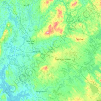
Name: County Longford topographic map, elevation, terrain.
Location: County Longford, Leinster, Ireland (53.52183 -8.03618 53.94208 -7.37492)
Average elevation: 73 m
Minimum elevation: 33 m
Maximum elevation: 273 m
Thank you for supporting this site ❤️
Make a donation
Make a donation
Other topographic maps
Click on a map to view its topography, its elevation and its terrain.