
Thank you for supporting this site ❤️
Make a donation
Make a donation
Frontenac County topographic map
Click on the map to display elevation.
Thank you for supporting this site ❤️
Make a donation
Make a donation
About this map
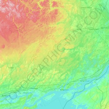
Name: Frontenac County topographic map, elevation, terrain.
Location: Frontenac County, Eastern Ontario, Ontario, Canada (44.01483 -77.22179 45.22195 -76.16181)
Average elevation: 169 m
Minimum elevation: 70 m
Maximum elevation: 492 m
Thank you for supporting this site ❤️
Make a donation
Make a donation
Other topographic maps
Click on a map to view its topography, its elevation and its terrain.
Starkey Hill Conservation Area
Canada > Ontario > Wellington County > Puslinch > Arkell
Average elevation: 348 m
Little Current
Canada > Ontario > Manitoulin District > Northeastern Manitoulin and the Islands
Average elevation: 193 m
Thank you for supporting this site ❤️
Make a donation
Make a donation
Thank you for supporting this site ❤️
Make a donation
Make a donation