
Thank you for supporting this site ❤️
Make a donation
Make a donation
Elvas topographic map
Click on the map to display elevation.
Thank you for supporting this site ❤️
Make a donation
Make a donation
About this map
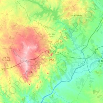
Name: Elvas topographic map, elevation, terrain.
Location: Elvas, Portalegre, Portugal (38.75150 -7.42429 39.05719 -7.03286)
Average elevation: 258 m
Minimum elevation: 143 m
Maximum elevation: 492 m
Thank you for supporting this site ❤️
Make a donation
Make a donation
Other topographic maps
Click on a map to view its topography, its elevation and its terrain.