
Thank you for supporting this site ❤️
Make a donation
Make a donation
Holy Cross Voivodeship topographic map
Click on the map to display elevation.
Thank you for supporting this site ❤️
Make a donation
Make a donation
About this map
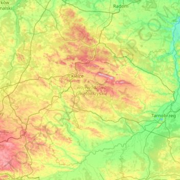
Name: Holy Cross Voivodeship topographic map, elevation, terrain.
Location: Holy Cross Voivodeship, Poland (50.18545 19.70430 51.34245 21.86926)
Average elevation: 229 m
Minimum elevation: 117 m
Maximum elevation: 601 m
Thank you for supporting this site ❤️
Make a donation
Make a donation
Other topographic maps
Click on a map to view its topography, its elevation and its terrain.
Thank you for supporting this site ❤️
Make a donation
Make a donation
Thank you for supporting this site ❤️
Make a donation
Make a donation
Kiernozia-Parcela
Poland > Łódź Voivodeship > Łowicz County > Kiernozia > Kiernozia-Parcela
Average elevation: 103 m