
Make a donation
Aleppo Governorate topographic map
Click on the map to display elevation.
Make a donation
Aleppo Governorate
The average elevation of the terrain is 379 metres (1,243 ft). The surface gradually slopes down in north-south and west-east directions, undulating gently with an amplitude of 10–30 m for each wave. The lowlands are covered with combined Paleozoic and Mesozoic sediments that average 4–5 km in thickness over the whole surface.
Make a donation
About this map
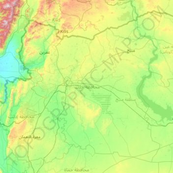
Name: Aleppo Governorate topographic map, elevation, terrain.
Location: Aleppo Governorate, Syria (35.38381 36.54368 36.92412 38.72058)
Average elevation: 439 m
Minimum elevation: 77 m
Maximum elevation: 2,182 m
Make a donation
Other topographic maps
Click on a map to view its topography, its elevation and its terrain.
An Nabk
Syria > Rif Dimashq Governorate
An-Nabek or Al-Nabek (Arabic: ٱلنَّبْك, romanized: an-Nabk) is a Syrian city administratively belonging to Rif Dimashq and the capital of the Qalamoun. Located 81 kilometers (50 mi) north of Damascus and south of Homs. It has an altitude of 1255 meters. According to the Syria Central Bureau of…
Average elevation: 1,304 m
Make a donation