
Thank you for supporting this site ❤️
Make a donation
Make a donation
Knúkin topographic map
Click on the map to display elevation.
Thank you for supporting this site ❤️
Make a donation
Make a donation
About this map
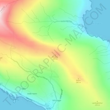
Name: Knúkin topographic map, elevation, terrain.
Location: Knúkin, Sumba, Suðuroyar sýsla, 970, Færøerne (61.41615 -6.70858 61.41625 -6.70848)
Average elevation: 163 m
Minimum elevation: -10 m
Maximum elevation: 436 m
Thank you for supporting this site ❤️
Make a donation
Make a donation