
Thank you for supporting this site ❤️
Make a donation
Make a donation
Krakow topographic map
Click on the map to display elevation.
Thank you for supporting this site ❤️
Make a donation
Make a donation
About this map
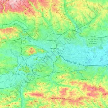
Name: Krakow topographic map, elevation, terrain.
Location: Krakow, Lesser Poland Voivodeship, Poland (49.96767 19.79224 50.12613 20.21735)
Average elevation: 263 m
Minimum elevation: 189 m
Maximum elevation: 469 m
Thank you for supporting this site ❤️
Make a donation
Make a donation
Other topographic maps
Click on a map to view its topography, its elevation and its terrain.
Przełęcz Spytkowicka (Bory)
Poland > Lesser Poland Voivodeship > Nowy Targ County > Podwilk > Więcierska
Average elevation: 694 m