
Thank you for supporting this site ❤️
Make a donation
Make a donation
Hanko topographic map
Click on the map to display elevation.
Thank you for supporting this site ❤️
Make a donation
Make a donation
About this map
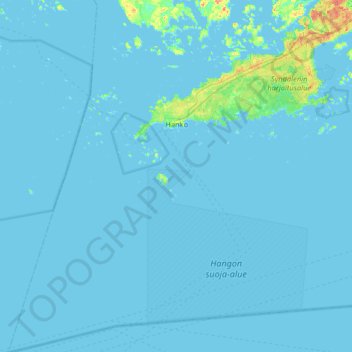
Name: Hanko topographic map, elevation, terrain.
Location: Hanko, Raseborg Sub-Region, Uusimaa, Mainland Finland, Finland (59.61100 22.65893 59.93718 23.29518)
Average elevation: 2 m
Minimum elevation: -2 m
Maximum elevation: 37 m
Thank you for supporting this site ❤️
Make a donation
Make a donation
Other topographic maps
Click on a map to view its topography, its elevation and its terrain.