
Nicobar Islands topographic map
Interactive map
Click on the map to display elevation.
About this map
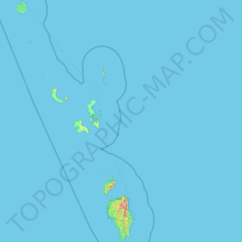
Name: Nicobar Islands topographic map, elevation, terrain.
Location: Nicobar Islands, Nicobar, Andaman and Nicobar Islands, India (6.75633 92.71865 9.25622 93.94684)
Average elevation: 2 m
Minimum elevation: 0 m
Maximum elevation: 538 m
Other topographic maps
Click on a map to view its topography, its elevation and its terrain.
North and Middle Andaman
India > Andaman and Nicobar Islands
North and Middle Andaman, Andaman and Nicobar Islands, 744210, India
Average elevation: 4 m
Great Channel
India > Andaman and Nicobar Islands
Great Channel, Andaman and Nicobar Islands, India
Average elevation: 0 m
South Andaman
India > Andaman and Nicobar Islands
South Andaman, Andaman and Nicobar Islands, India
Average elevation: 3 m