Geolocate

Gibaja topographic map

Click on the map to display elevation.

About this map

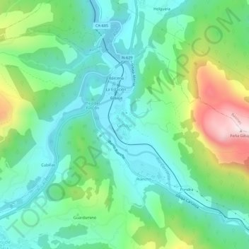
Name: Gibaja topographic map, elevation, terrain.

Location: Gibaja, Ramales de la Victoria, Cantabria, 39809, Spain (43.25679 -3.45642 43.29679 -3.41642)

Average elevation: 212 m

Minimum elevation: 36 m

Maximum elevation: 663 m

Other topographic maps

Click on a map to view its topography, its elevation and its terrain.

Polanco

Spain > Cantabria

Average elevation: 54 m

Polanco

Spain > Cantabria

Average elevation: 54 m

Comillas

Spain > Cantabria

Average elevation: 84 m

Polanco

Spain > Cantabria

Average elevation: 54 m

Potes

Spain > Cantabria

The town of Potes is located at the confluence of four valleys, near where the River Quiviesa flows in the River Deva, the latter born at altitudes of the Picos de Europa. Like the rest of the Liébana region, Potes enjoys a Mediterranean microclimate that allows the cultivation of the vines, walnut and…

Average elevation: 490 m

Molledo

Spain > Cantabria

Average elevation: 618 m

Polanco

Spain > Cantabria

Average elevation: 54 m

Guriezo

Spain > Cantabria

Average elevation: 298 m

Saro

Spain > Cantabria

Average elevation: 275 m

Santander

Spain > Cantabria

Average elevation: 10 m

Escalante

Spain > Cantabria

Average elevation: 46 m

Pesaguero

Spain > Cantabria

Average elevation: 1,125 m

Campoo de Yuso

Spain > Cantabria

Average elevation: 885 m

Voto

Spain > Cantabria

Average elevation: 230 m

Luena

Spain > Cantabria

Average elevation: 739 m

Piélagos

Spain > Cantabria

Average elevation: 61 m

Trasmiera

Spain > Cantabria

Average elevation: 187 m

Soba

Spain > Cantabria

Average elevation: 792 m

Rionansa

Spain > Cantabria

Average elevation: 640 m

Castro-Urdiales

Spain > Cantabria

Average elevation: 189 m

Cabezón de la Sal

Spain > Cantabria

Average elevation: 231 m

Cantabria

Spain > Cantabria

Towards the south are higher mountains, the tops of which form the watershed between the drainage basins of the Rivers Ebro, Duero and the rivers that flow into the Bay of Biscay. These peaks generally exceed 1,500 m (4,900 ft) from the Pass of San Glorio in the west to the Pass of Los Tornos in the eastern…

Average elevation: 609 m

Potes

Spain > Cantabria

The town of Potes is located at the confluence of four valleys, near where the River Quiviesa flows in the River Deva, the latter born at altitudes of the Picos de Europa. Like the rest of the Liébana region, Potes enjoys a Mediterranean microclimate that allows the cultivation of the vines, walnut and…

Average elevation: 490 m

Colindres

Spain > Cantabria

Average elevation: 37 m

Vega de Pas

Spain > Cantabria

Average elevation: 741 m

Reinosa

Spain > Cantabria

Average elevation: 861 m

Camargo

Spain > Cantabria > Camargo

Average elevation: 63 m

Puente Viesgo

Spain > Cantabria

Average elevation: 249 m

Polaciones

Spain > Cantabria > Polaciones

Average elevation: 1,269 m

Torrelavega

Spain > Cantabria > Besaya > Torrelavega > Torres > Torrelavega

Average elevation: 40 m

Suances

Spain > Cantabria

Average elevation: 39 m

Miengo

Spain > Cantabria > Santander > Miengo

Average elevation: 27 m

Alfoz de Lloredo

Spain > Cantabria

Average elevation: 111 m

Escalante

Spain > Cantabria

Average elevation: 46 m