
Thank you for supporting this site ❤️
Make a donation
Make a donation
Vallée du Lys topographic map
Click on the map to display elevation.
Thank you for supporting this site ❤️
Make a donation
Make a donation
Vallée du Lys
La vallée du Lis, ou vallée du Lys, est une petite vallée d'altitude des Pyrénées françaises s'ouvrant sur la vallée de Luchon (département de la Haute-Garonne, région Occitanie). Elle tient son nom du Lys, petite rivière affluent de la Pique.
Thank you for supporting this site ❤️
Make a donation
Make a donation
About this map
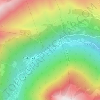
Name: Vallée du Lys topographic map, elevation, terrain.
Average elevation: 1,436 m
Minimum elevation: 1,007 m
Maximum elevation: 2,032 m
Thank you for supporting this site ❤️
Make a donation
Make a donation
Other topographic maps
Click on a map to view its topography, its elevation and its terrain.
Refuge du Maupas
France > Occitanie > Haute-Garonne > Castillon-de-Larboust
Average elevation: 2,241 m