
Make a donation
Benito Juárez topographic map
Click on the map to display elevation.
Make a donation
Benito Juárez
It has a territory of 26.63 km2 (2,661.5 hectares), which is 1.8% of Mexico City, with an average altitude of 2,242 metres. It consists of 56 neighborhoods called "colonias" and three major apartment complexes (unidades habitacionales) which cover 2,210 city blocks and through which some of the most important city thoroughfares pass. The borough is nearly entirely residential with a socioeconomic level of middle class to upper middle class.
Make a donation
About this map
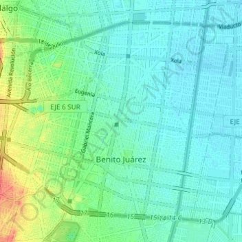
Name: Benito Juárez topographic map, elevation, terrain.
Location: Benito Juárez, Mexico City, Mexico (19.35689 -99.19214 19.40406 -99.13094)
Average elevation: 2,244 m
Minimum elevation: 2,231 m
Maximum elevation: 2,282 m
Make a donation
Other topographic maps
Click on a map to view its topography, its elevation and its terrain.
Xochimilco
Much of the borough's land is former lakebed. Its main elevations include Xochitepec and Tlacualleli mountains along with two volcanoes named Teutli and Tzompol. It contains two natural rivers called Santiago and Tepapantla along with the various canals, which is what is left of the lake. The elevated areas of…
Average elevation: 2,241 m
Make a donation