
Make a donation
Saint-Genis-Pouilly topographic map
Click on the map to display elevation.
Make a donation
Saint-Genis-Pouilly
Saint-Genis-Pouilly is composed of two market towns (Saint-Genis and Pouilly) and two hamlets (Pregnin and Flies). The two market towns have both continued to expand and now practically merge into one, however the two hamlets still remain separate from each other and from the two towns. The elevation of the commune varies from 419 m (at the extreme south of the commune, to the confluence of the rivers Allondon and Nant de l'Ecra) to 502 m (at the extreme north of the commune, in the village of Flies). The commune is situated at the limit between the plains surrounding Geneva and the first foothills of the Jura. As indicated on the map opposite, the communes surrounding Saint-Genis-Pouilly are: Thoiry, Sergy, Crozet, Chevry, Prévessin-Moëns and Satigny (Swiss).
Make a donation
About this map
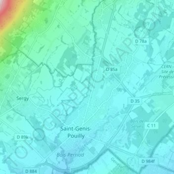
Name: Saint-Genis-Pouilly topographic map, elevation, terrain.
Average elevation: 485 m
Minimum elevation: 425 m
Maximum elevation: 1,065 m
Make a donation
Other topographic maps
Click on a map to view its topography, its elevation and its terrain.
Make a donation
Make a donation
Make a donation
Mas Finet
France > Auvergne-Rhône-Alpes > Ain > Villieu-Loyes-Mollon > Mollon
Average elevation: 256 m
Make a donation
Make a donation
Étang du Chêne
France > Auvergne-Rhône-Alpes > Ain > Saint-André-sur-Vieux-Jonc > Domaine du Suc
Average elevation: 259 m