
Make a donation
Saint-Léger-sur-Dheune topographic map
Click on the map to display elevation.
Make a donation
About this map
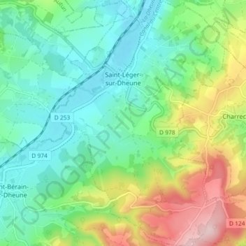
Name: Saint-Léger-sur-Dheune topographic map, elevation, terrain.
Average elevation: 309 m
Minimum elevation: 227 m
Maximum elevation: 489 m
Make a donation
Other topographic maps
Click on a map to view its topography, its elevation and its terrain.
Commune
France > Bourgogne-Franche-Comté > Saône-et-Loire > Martigny-le-Comte
Average elevation: 353 m
Parc Georges Nouelle
France > Bourgogne-Franche-Comté > Saône-et-Loire > Chalon-sur-Saône
Average elevation: 180 m
Make a donation
Make a donation
Le Saumon
France > Bourgogne-Franche-Comté > Saône-et-Loire > Dampierre-en-Bresse
Average elevation: 194 m
Verneuil
France > Bourgogne-Franche-Comté > Saône-et-Loire > Charnay-lès-Mâcon
Average elevation: 228 m
Make a donation
Loyse
France > Bourgogne-Franche-Comté > Saône-et-Loire > La Chapelle-de-Guinchay
Average elevation: 197 m
Les Guillons
France > Bourgogne-Franche-Comté > Saône-et-Loire > Saint-Amour-Bellevue
Average elevation: 287 m
Make a donation
Martoret
France > Bourgogne-Franche-Comté > Saône-et-Loire > Saint-Maurice-de-Satonnay
Average elevation: 228 m
La Grange du Bois
France > Bourgogne-Franche-Comté > Saône-et-Loire > Crêches-sur-Saône
Average elevation: 199 m
Château de Saint-Aubin
France > Bourgogne-Franche-Comté > Saône-et-Loire > Saint-Aubin-sur-Loire
Average elevation: 238 m
Make a donation
Cité Ouvrière de la Combe des Mineurs
France > Bourgogne-Franche-Comté > Saône-et-Loire > Le Creusot
Average elevation: 390 m
Make a donation
Les Bouchats
France > Bourgogne-Franche-Comté > Saône-et-Loire > Saint-Étienne-en-Bresse
Average elevation: 201 m
Le Gros Mont
France > Bourgogne-Franche-Comté > Saône-et-Loire > La Roche-Vineuse
Average elevation: 305 m
Make a donation
Besanceuil
France > Bourgogne-Franche-Comté > Saône-et-Loire > Bonnay-Saint-Ythaire
Average elevation: 272 m
Make a donation
La Grange des Bois
France > Bourgogne-Franche-Comté > Saône-et-Loire > Digoin
Average elevation: 245 m
Le Bourgneuf
France > Bourgogne-Franche-Comté > Saône-et-Loire > La Chapelle-Saint-Sauveur
Average elevation: 202 m
La Grande Trémaillère
France > Bourgogne-Franche-Comté > Saône-et-Loire > Saint-Usuge
Average elevation: 202 m
Make a donation
Les Layes
France > Bourgogne-Franche-Comté > Saône-et-Loire > Saint-Pierre-le-Vieux
Average elevation: 470 m
Les Fargets
France > Bourgogne-Franche-Comté > Saône-et-Loire > Romanèche-Thorins
Average elevation: 210 m
Make a donation
La Croix Rouge
France > Bourgogne-Franche-Comté > Saône-et-Loire > Saint-Germain-du-Bois
Average elevation: 201 m
Make a donation
Les Fougerets
France > Bourgogne-Franche-Comté > Saône-et-Loire > Broye > Les Périzans
Average elevation: 413 m
Make a donation
La Croix
France > Bourgogne-Franche-Comté > Saône-et-Loire > Varennes-lès-Mâcon
Average elevation: 183 m
Make a donation
Villargeau
France > Bourgogne-Franche-Comté > Saône-et-Loire > L'Abergement-Sainte-Colombe
Average elevation: 208 m
La Petite Gravière
France > Bourgogne-Franche-Comté > Saône-et-Loire > Frontenaud
Average elevation: 196 m
Make a donation
Les Plates
France > Bourgogne-Franche-Comté > Saône-et-Loire > L'Abergement-Sainte-Colombe
Average elevation: 204 m
Montbrillant
France > Bourgogne-Franche-Comté > Saône-et-Loire > La Chapelle-Naude
Average elevation: 191 m
Make a donation
Le Pommoy
France > Bourgogne-Franche-Comté > Saône-et-Loire > Roussillon-en-Morvan
Average elevation: 597 m
Le Beuillet
France > Bourgogne-Franche-Comté > Saône-et-Loire > Broye > Mont-Fenaud
Average elevation: 378 m
Make a donation
Les Croches
France > Bourgogne-Franche-Comté > Saône-et-Loire > Saint-Amour-Bellevue
Average elevation: 250 m
Les Poulets
France > Bourgogne-Franche-Comté > Saône-et-Loire > Saint-Amour-Bellevue
Average elevation: 280 m
Bois du Verne
France > Bourgogne-Franche-Comté > Saône-et-Loire > Montceau-les-Mines
Average elevation: 297 m
Make a donation
Make a donation
Le Pelleret
France > Bourgogne-Franche-Comté > Saône-et-Loire > Saint-Martin-Belle-Roche
Average elevation: 201 m
Make a donation
Charcuble
France > Bourgogne-Franche-Comté > Saône-et-Loire > Bissy-la-Mâconnaise
Average elevation: 384 m
Poutot
France > Bourgogne-Franche-Comté > Saône-et-Loire > Saint-Germain-du-Plain
Average elevation: 185 m
Make a donation
Frêne
France > Bourgogne-Franche-Comté > Saône-et-Loire > Lournand > Sous Lourdon
Average elevation: 352 m
Château de Sainte-Croix
France > Bourgogne-Franche-Comté > Saône-et-Loire > Sainte-Croix-en-Bresse > Les Cornets
Average elevation: 195 m
Make a donation
Bonzon
France > Bourgogne-Franche-Comté > Saône-et-Loire > Saint-Gengoux-de-Scissé
Average elevation: 339 m
Make a donation
Bois du Verne
France > Bourgogne-Franche-Comté > Saône-et-Loire > Montceau-les-Mines
Average elevation: 297 m
Corberan
France > Bourgogne-Franche-Comté > Saône-et-Loire > Saint-Étienne-en-Bresse
Average elevation: 197 m
Make a donation
Château de Chaumont
France > Bourgogne-Franche-Comté > Saône-et-Loire > Saint-Bonnet-de-Joux > Château de Chaumont
Average elevation: 389 m
Make a donation
Charnay
France > Bourgogne-Franche-Comté > Saône-et-Loire > Saint-Martin-de-Salencey
Average elevation: 357 m
Make a donation