
Thank you for supporting this site ❤️
Make a donation
Make a donation
Villarrica topographic map
Click on the map to display elevation.
Thank you for supporting this site ❤️
Make a donation
Make a donation
Villarrica
Other lakes found nearby include Calafquén, Caburgua, Huilipilún and Colico. In the summer water sports and sunbathing are popular activities in the warm temperatures experienced at the low altitudes ranging from 200 to 500m above sea level.
Thank you for supporting this site ❤️
Make a donation
Make a donation
About this map
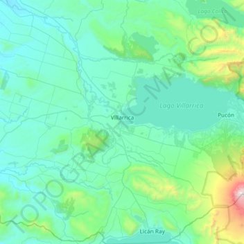
Name: Villarrica topographic map, elevation, terrain.
Average elevation: 421 m
Minimum elevation: 116 m
Maximum elevation: 2,831 m
Thank you for supporting this site ❤️
Make a donation
Make a donation