
Make a donation
Uri topographic map
Click on the map to display elevation.
Make a donation
Uri
The highest elevation in the canton, and in the Urner Alps as a whole, is the Dammastock, at 3,630 m (11,910 ft), north of the Furka Pass."Dammastock 3630 m". hikr.org (in German). Archived from the original on 19 September 2020. Retrieved 29 November 2020. The Glarus and Lepontine Alps ranges are also partially situated in the canton of Uri.
Make a donation
About this map
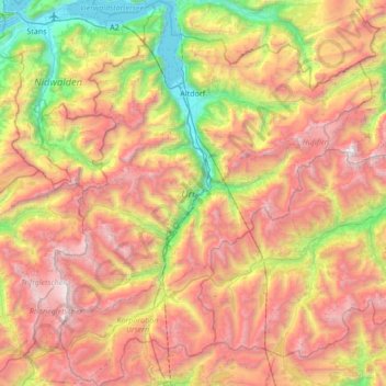
Name: Uri topographic map, elevation, terrain.
Location: Uri, Switzerland (46.52763 8.39736 46.99341 8.95780)
Average elevation: 1,886 m
Minimum elevation: 426 m
Maximum elevation: 3,594 m
Make a donation
Other topographic maps
Click on a map to view its topography, its elevation and its terrain.
Bellerive VD
Switzerland > Vaud > District de la Broye-Vully > Vully-les-Lacs
Average elevation: 483 m
Make a donation
Kiental
Switzerland > Bern > Frutigen-Niedersimmental administrative district > Reichenbach im Kandertal
Average elevation: 1,363 m
Make a donation
Oberwald
Switzerland > Wallis > Goms > Obergoms
It is situated at an elevation of 1,377 m and had a population of 277 in December 2007. It is located at the end of the Goms, directly before the Furka and Grimsel passes, underneath the Rhône River source at the Rhône Glacier. It is also the startpoint of the Furka Tunnel. Most inhabitants live off tourism…
Average elevation: 1,744 m
Männlichen
Switzerland > Bern > Interlaken-Oberhasli administrative district > Grindelwald
Average elevation: 1,709 m
Make a donation
Lauberhorn
Switzerland > Bern > Interlaken-Oberhasli administrative district > Grindelwald
Average elevation: 1,975 m
Make a donation
Gstaad
Switzerland > Bern > Obersimmental-Saanen administrative district > Gstaad
Average elevation: 1,242 m
Make a donation
Bern
Switzerland > Bern > Bern-Mittelland administrative district > Bern
Bern is built on very uneven ground. An elevation difference of up to 60 metres exists between the inner city districts on the Aare (Matte, Marzili) and the higher ones (Kirchenfeld, Länggasse).
Average elevation: 643 m