
Thank you for supporting this site ❤️
Make a donation
Make a donation
Pfänder topographic map
Click on the map to display elevation.
Thank you for supporting this site ❤️
Make a donation
Make a donation
Pfänder
Der Pfänder ist der zweithöchste Punkt des Höhenrückens, der sich im Osten des Bodensees, oberhalb von Bregenz und Lochau, über eine Strecke von etwa 5 Kilometern hinzieht. Der höchste Gipfel der Kette ist der Hochberg (1069 m).
Thank you for supporting this site ❤️
Make a donation
Make a donation
About this map
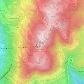
Name: Pfänder topographic map, elevation, terrain.
Location: Pfänder, Lochau, Bezirk Bregenz, Vorarlberg, 6911, Österreich (47.50732 9.78015 47.50742 9.78025)
Average elevation: 826 m
Minimum elevation: 476 m
Maximum elevation: 1,055 m
Thank you for supporting this site ❤️
Make a donation
Make a donation
Other topographic maps
Click on a map to view its topography, its elevation and its terrain.