
Thank you for supporting this site ❤️
Make a donation
Make a donation
Luolong District topographic map
Click on the map to display elevation.
Thank you for supporting this site ❤️
Make a donation
Make a donation
About this map
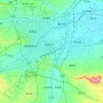
Name: Luolong District topographic map, elevation, terrain.
Location: Luolong District, Luoyang, Henan, China (34.50572 112.35652 34.71201 112.65452)
Average elevation: 198 m
Minimum elevation: 115 m
Maximum elevation: 842 m
Thank you for supporting this site ❤️
Make a donation
Make a donation
Other topographic maps
Click on a map to view its topography, its elevation and its terrain.