
Make a donation
Matosinhos topographic map
Click on the map to display elevation.
Make a donation
Matosinhos
At the end of the Bronze Age, much like most of the northwest peninsula, settlements expanded into proto-urban agglomerations at high altitudes (castros), associated with a culture with specific characteristics that predominated until the 1st century. Until today there still exist vestiges of castros dotting the landscapes, such as the assets collected from the Castro of Monte Castelo in Guifões. The natural conditions and navigability of the Leça River estuary assisted maritime transport, that depended on the transport of a diverse flow of merchandise from throughout Imperial Roman. Here, the products were offloaded and redistributed to other sites within the region.
Make a donation
About this map
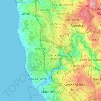
Name: Matosinhos topographic map, elevation, terrain.
Location: Matosinhos, Porto, Portugal (41.17149 -8.72916 41.27311 -8.59545)
Average elevation: 44 m
Minimum elevation: -3 m
Maximum elevation: 145 m
Make a donation
Other topographic maps
Click on a map to view its topography, its elevation and its terrain.
Make a donation
Make a donation
Make a donation
Santa Marinha do Zêzere
Portugal > Porto > Santa Marinha do Zêzere > Santa Marinha do Zêzere
Average elevation: 425 m
Make a donation
Make a donation
São Tomé de Covelas
Portugal > Porto > Santa Cruz do Douro e São Tomé de Covelas
Average elevation: 356 m