
Thank you for supporting this site ❤️
Make a donation
Make a donation
Itajubá topographic map
Click on the map to display elevation.
Thank you for supporting this site ❤️
Make a donation
Make a donation
Itajubá
Itajubá is a municipality in southeastern Minas Gerais state of the Federative Republic of Brazil. It lies in a valley by the Sapucaí river and has terrain elevations ranging from 827 to 1500 metres, occupying an area of 290.45 km2 (112.14 mi2), with a population of 97,334 people (2020 est). Neighboring the city are the mountain slopes of the Serra da Mantiqueira range. The climate sees heavy rain in the summer months with dry weather in the winter.
Thank you for supporting this site ❤️
Make a donation
Make a donation
About this map
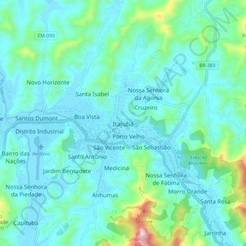
Name: Itajubá topographic map, elevation, terrain.
Average elevation: 923 m
Minimum elevation: 837 m
Maximum elevation: 1,378 m
Thank you for supporting this site ❤️
Make a donation
Make a donation