
Thank you for supporting this site ❤️
Make a donation
Make a donation
Motovun topographic map
Click on the map to display elevation.
Thank you for supporting this site ❤️
Make a donation
Make a donation
About this map
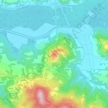
Name: Motovun topographic map, elevation, terrain.
Location: Motovun, Općina Motovun, Istria County, 52424, Croatia (45.31673 13.80821 45.35673 13.84821)
Average elevation: 80 m
Minimum elevation: -2 m
Maximum elevation: 348 m
Thank you for supporting this site ❤️
Make a donation
Make a donation
Other topographic maps
Click on a map to view its topography, its elevation and its terrain.