
Make a donation
Queensland topographic map
Click on the map to display elevation.
Make a donation
Queensland
Queensland's topography is characterized by a diverse landscape that includes coastal plains, mountain ranges, plateaus, and expansive inland areas. The Great Dividing Range runs parallel to the state's eastern coast, forming a series of mountain ranges, plateaus, and upland areas. This range influences the climate and hydrology of the region, acting as a watershed that directs river systems either toward the Pacific Ocean or inland areas. The coastal region east of the range features fertile plains and river valleys, supporting agriculture and dense population centers. In contrast, the western side transitions into arid and semi-arid landscapes, characterized by vast plains and low-relief areas. Notably, the Wet Tropics of Queensland, stretching from Townsville to Cooktown, encompasses rugged terrains with highlands, tablelands, and escarpments, including Australia's highest waterfall, Wallaman Falls. The state's highest peak, Mount Bartle Frere, rises to 1,622 meters (5,321 feet) in this region. Additionally, Queensland's coastline is adorned with significant sand islands such as K'gari (Fraser Island), Moreton, and North Stradbroke, with K'gari being the largest sand island globally.
Make a donation
About this map
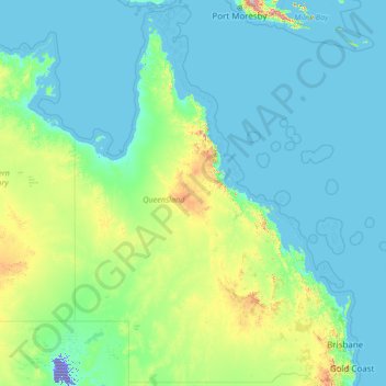
Name: Queensland topographic map, elevation, terrain.
Location: Queensland, Australia (-29.17927 137.99465 -9.08801 153.61160)
Average elevation: 122 m
Minimum elevation: -16 m
Maximum elevation: 3,313 m
Make a donation
Other topographic maps
Click on a map to view its topography, its elevation and its terrain.
Make a donation
Make a donation
Make a donation
Make a donation