
Thank you for supporting this site ❤️
Make a donation
Make a donation
Jiquilpan topographic map
Click on the map to display elevation.
Thank you for supporting this site ❤️
Make a donation
Make a donation
About this map
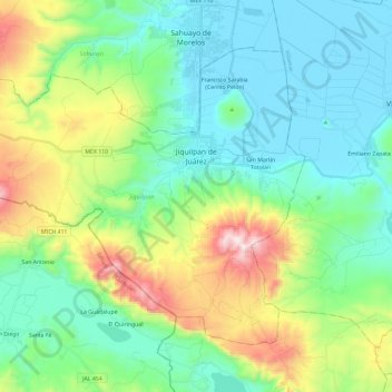
Name: Jiquilpan topographic map, elevation, terrain.
Location: Jiquilpan, Michoacán, Mexico (19.88327 -102.88926 20.05165 -102.65363)
Average elevation: 1,787 m
Minimum elevation: 1,523 m
Maximum elevation: 2,510 m
Thank you for supporting this site ❤️
Make a donation
Make a donation
Other topographic maps
Click on a map to view its topography, its elevation and its terrain.