
Thank you for supporting this site ❤️
Make a donation
Make a donation
Klæbu topographic map
Click on the map to display elevation.
Thank you for supporting this site ❤️
Make a donation
Make a donation
About this map
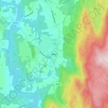
Name: Klæbu topographic map, elevation, terrain.
Location: Klæbu, Trondheim, Trøndelag, 7540, Norge (63.27902 10.46406 63.31902 10.50406)
Average elevation: 215 m
Minimum elevation: 91 m
Maximum elevation: 496 m
Thank you for supporting this site ❤️
Make a donation
Make a donation
Other topographic maps
Click on a map to view its topography, its elevation and its terrain.