
Make a donation
Omsk topographic map
Click on the map to display elevation.
Make a donation
Omsk
Omsk is situated on the south of the West Siberian Plain along the banks of the north-flowing Irtysh at its confluence with the Om River. The city has an elevation of 87 meters (285 ft) above mean sea level at its highest point.
Make a donation
About this map
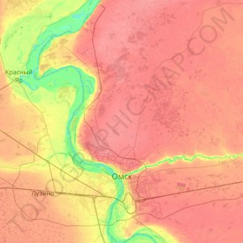
Name: Omsk topographic map, elevation, terrain.
Location: Omsk, Omsk Oblast, Siberian Federal District, 644000, Russia (54.82404 73.09753 55.42657 73.62868)
Average elevation: 107 m
Minimum elevation: 63 m
Maximum elevation: 143 m
Make a donation
Other topographic maps
Click on a map to view its topography, its elevation and its terrain.
Omsk
Russia > Omsk Oblast > Omsk > Omsk
Omsk is situated in the south of the West Siberian Plain along the banks of the north-flowing Irtysh at its confluence with the Om River. The city has an elevation of 87 meters (285 ft) above mean sea level at its highest point.
Average elevation: 105 m