
Thank you for supporting this site ❤️
Make a donation
Make a donation
Valencia topographic map
Click on the map to display elevation.
Thank you for supporting this site ❤️
Make a donation
Make a donation
Valencia
The maximum of precipitation occurs in autumn, coinciding with the time of the year when cold drop (gota fría) episodes of heavy rainfall—associated to cut-off low pressure systems at high altitude— are common along the Western mediterranean coast. The year-on-year variability in precipitation may be, however, considerable.
Thank you for supporting this site ❤️
Make a donation
Make a donation
About this map
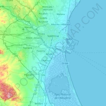
Name: Valencia topographic map, elevation, terrain.
Average elevation: 37 m
Minimum elevation: -6 m
Maximum elevation: 346 m
Thank you for supporting this site ❤️
Make a donation
Make a donation