
Thank you for supporting this site ❤️
Make a donation
Make a donation
Büdingen topographic map
Click on the map to display elevation.
Thank you for supporting this site ❤️
Make a donation
Make a donation
Büdingen
Buding liegt an der Canner, etwa zwölf Kilometer östlich von Thionville auf einer Höhe zwischen 170 und 306 m über dem Meeresspiegel. Das Gemeindegebiet umfasst 6,35 km².
Thank you for supporting this site ❤️
Make a donation
Make a donation
About this map
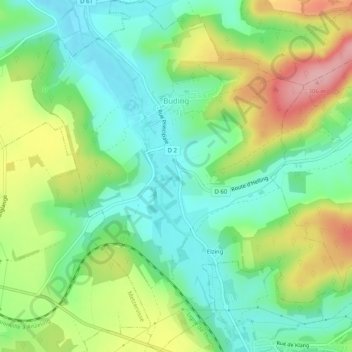
Name: Büdingen topographic map, elevation, terrain.
Average elevation: 220 m
Minimum elevation: 166 m
Maximum elevation: 314 m
Thank you for supporting this site ❤️
Make a donation
Make a donation