
Make a donation
Les Ménuires topographic map
Click on the map to display elevation.
Make a donation
Les Ménuires
The resort was founded in 1964 and has an altitude range of 1,850 m (6,070 ft).
Make a donation
About this map
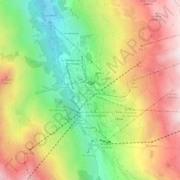
Name: Les Ménuires topographic map, elevation, terrain.
Average elevation: 2,063 m
Minimum elevation: 1,559 m
Maximum elevation: 2,608 m
Make a donation
Other topographic maps
Click on a map to view its topography, its elevation and its terrain.
Saint-Jean-de-Maurienne
France > Auvergne-Rhône-Alpes > Savoy
Saint-Jean-de-Maurienne is on the route of the future Lyon-Turin rail link. Homes, businesses, the current railway station and the rescue centre are affected by the project. The Lyon Turin Railway company (LTF) which manages the construction projects plans to build new railway station in the Sous-le-Bourg…
Average elevation: 946 m
Make a donation
Saint-Michel-de-Maurienne
France > Auvergne-Rhône-Alpes > Savoy
Saint-Michel-de-Maurienne has a oceanic climate (Köppen climate classification Cfb). The station is located at an altitude of 700 m (2,300 ft); due to its location on a leeward slope, there is significantly less precipitation than nearby areas. It is quite common to exceed 30 °C (86 °F) in summer, sometimes…
Average elevation: 1,590 m
Aix-les-Bains
France > Auvergne-Rhône-Alpes > Savoy
Aix-Les-Bains is located in the southeast of France, 107 kilometres (66 mi) east of Lyon. The town is located in a corridor between the mountain of Mont Revard, the first natural rampart of the Massif des Bauges to the east and the Lac du Bourget, the largest natural lake of France to the west. Thus, the city…
Average elevation: 348 m
Make a donation
Le Charvet
France > Auvergne-Rhône-Alpes > Savoy > Bourg-Saint-Maurice > Arc 1800
Average elevation: 1,651 m
Bonneval-sur-Arc
France > Auvergne-Rhône-Alpes > Savoy
Bonneval-sur-Arc features an alpine climate due to its high elevation, just under the tree line. Its climate is characterised by very cold, snowy winters and cool, stormy summers.
Average elevation: 2,636 m
Make a donation
Make a donation
Make a donation
Montaimont
France > Auvergne-Rhône-Alpes > Savoy > Saint-François-Longchamp
Average elevation: 1,678 m
Make a donation