
Make a donation
Wałbrzych topographic map
Click on the map to display elevation.
Make a donation
Wałbrzych
Wałbrzych is located in the Central Sudeten Mountains, near the border with the Czech Republic and Germany. The city is located by the Pełcznica River at 450-500 m above sea level in a picturesque structural basin of Wałbrzych above which there are wooded ranges of the Wałbrzych Mountains. The highest elevation in the city is Mount Borowa, also known as the Black Mountain, 853 m (2798ft) above sea level, with an observation tower since 2007, which is the highest peak of the Wałbrzych mountains.
Make a donation
About this map
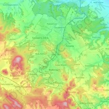
Name: Wałbrzych topographic map, elevation, terrain.
Location: Wałbrzych, Lower Silesian Voivodeship, Poland (50.71609 16.22718 50.85414 16.35527)
Average elevation: 479 m
Minimum elevation: 276 m
Maximum elevation: 850 m
Make a donation
Other topographic maps
Click on a map to view its topography, its elevation and its terrain.
Sudety
Poland > Lower Silesian Voivodeship > Ząbkowice Śląskie County > Starczówek
Average elevation: 293 m
Make a donation
Chałupniki
Poland > Lower Silesian Voivodeship > Lubań County > Świecie > Chałupniki
Average elevation: 403 m