
Make a donation
Vejle topographic map
Click on the map to display elevation.
Make a donation
Vejle
In a country where the highest natural elevation is only about 170 m (558 ft) above sea level, Vejle is known for the forested hills that rise to the north and south of the town and fjord.
Make a donation
About this map
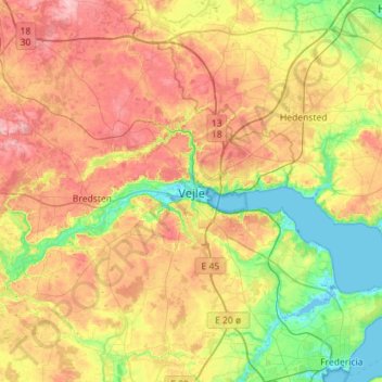
Name: Vejle topographic map, elevation, terrain.
Location: Vejle, Vejle Municipality, 7100, Denmark (55.54001 9.37332 55.86001 9.69332)
Average elevation: 60 m
Minimum elevation: -4 m
Maximum elevation: 135 m
Make a donation
Other topographic maps
Click on a map to view its topography, its elevation and its terrain.
Bornholm
Denmark > Capital Region of Denmark
The island is known as solskinsøen ("sunshine island") because of its weather and klippeøen ("rock island") because of its geology, which consists of granite, except along the southern coast. The heat from the summer is stored in the rock formations and the weather is quite warm until October. As a result of…
Average elevation: 33 m