
Thank you for supporting this site ❤️
Make a donation
Make a donation
Waldviertel topographic map
Click on the map to display elevation.
Thank you for supporting this site ❤️
Make a donation
Make a donation
About this map
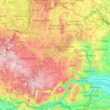
Name: Waldviertel topographic map, elevation, terrain.
Location: Waldviertel, Lower Austria, Austria (48.17114 14.69022 49.02052 15.95989)
Average elevation: 519 m
Minimum elevation: 175 m
Maximum elevation: 1,054 m
Thank you for supporting this site ❤️
Make a donation
Make a donation
Other topographic maps
Click on a map to view its topography, its elevation and its terrain.
Lahnberg
Austria > Lower Austria > Bezirk Neunkirchen > Schwarzau im Gebirge
Average elevation: 1,213 m