
Make a donation
Bruneck - Brunico topographic map
Click on the map to display elevation.
Make a donation
Bruneck - Brunico
Bruneck rises up in the middle of a wide valley (perhaps an ancient lake basin) and lies at the confluence of the Ahr with the Rienz, which itself flows into the Eisack river. Here the northern Tauferer Ahrntal side valley and the southern Val Badia of the Gran Ega creek join the broad Pustertal. Bruneck wide valley, located between the two straits of Kiens downstream and Percha upstream, delimited to the South by the circular elevation of Kronplatz and opened to the North in the Tauferer Tal (Val di Tures), owes its conformation and extent to the action of glaciers and, subsequently, to the erosive action of the waters.The municipal area stretches from the slopes of the Zillertal Alps in the west to the Rieserferner Group of the High Tauern range in the east. In the south rises the Kronplatz massif, part of the Dolomites, the Bruneck Hausberg with the Messner Mountain Museum Corones building designed by Zaha Hadid on top at an elevation of 2,275 metres (7,464 ft) and a popular ski area.
Make a donation
About this map
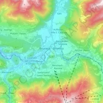
Name: Bruneck - Brunico topographic map, elevation, terrain.
Average elevation: 1,251 m
Minimum elevation: 784 m
Maximum elevation: 2,273 m
Make a donation