
Make a donation
Nyköping topographic map
Click on the map to display elevation.
Make a donation
Nyköping
The small river Kilaån separates Nyköping and Arnö, with that river being even narrower. Also separating Nyköping and Arnö is the so-called Stadsfjärden (the City bay), which is a bay stretching around the Arnö peninsula down to the neighboring municipality of Oxelösund. Stadsfjärden is primarily used for tourist shipping and canoeing, with an internationally renowned canoeing stadium being situated along the northern shore. The port is much smaller than Oxelösund's and is primarily used for civil traffic, as opposed to cargo shipments and ferry traffic which is dominated by nearby ports of Oxelösund and Nynäshamn. This is due to the port being some 15 kilometres from open sea as opposed to Oxelösund's position on the edge of the peninsula. Even though Nyköping is a relatively flat city there are some hills in the northern parts of the town, barely reaching 50 metres altitude. The city centre is essentially just above sea level and does not rise above 20 metres altitude, although it contains hills surrounding it.
Make a donation
About this map
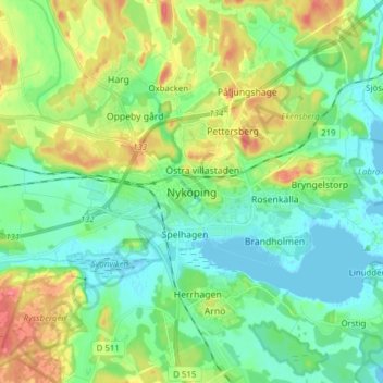
Name: Nyköping topographic map, elevation, terrain.
Average elevation: 25 m
Minimum elevation: -2 m
Maximum elevation: 94 m
Make a donation
Other topographic maps
Click on a map to view its topography, its elevation and its terrain.