
Butler topographic map
Interactive map
Click on the map to display elevation.
About this map
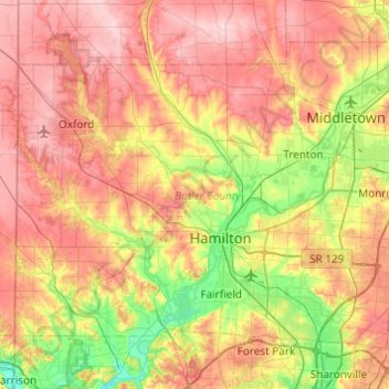
Name: Butler topographic map, elevation, terrain.
Location: Butler, Ohio, United States of America (39.29229 -84.81939 39.58954 -84.33204)
Average elevation: 245 m
Minimum elevation: 150 m
Maximum elevation: 341 m
Other topographic maps
Click on a map to view its topography, its elevation and its terrain.
Ottawa County
United States of America > Ohio
Ottawa County, Ohio, United States of America
Average elevation: 180 m
East Gardens
United States of America > Ohio > Northwood > East Gardens
East Gardens, Northwood, Wood County, Ohio, 43616:43619, United States of America
Average elevation: 188 m
Highland County
United States of America > Ohio
Highland County, Ohio, United States of America
Average elevation: 305 m