
Thank you for supporting this site ❤️
Make a donation
Make a donation
Ottignies-Louvain-la-Neuve topographic map
Click on the map to display elevation.
Thank you for supporting this site ❤️
Make a donation
Make a donation
About this map
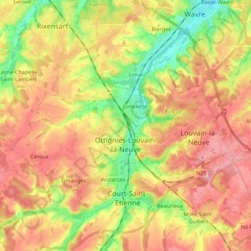
Name: Ottignies-Louvain-la-Neuve topographic map, elevation, terrain.
Average elevation: 103 m
Minimum elevation: 40 m
Maximum elevation: 155 m
Thank you for supporting this site ❤️
Make a donation
Make a donation
Other topographic maps
Click on a map to view its topography, its elevation and its terrain.
Thank you for supporting this site ❤️
Make a donation
Make a donation
Pré Delcourt
Belgium > Walloon Brabant > Nivelles > Chaumont-Gistoux > Chaumont
Average elevation: 127 m
Thank you for supporting this site ❤️
Make a donation
Make a donation
Thank you for supporting this site ❤️
Make a donation
Make a donation