
Thank you for supporting this site ❤️
Make a donation
Make a donation
Deira topographic map
Click on the map to display elevation.
Thank you for supporting this site ❤️
Make a donation
Make a donation
About this map
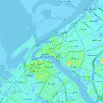
Name: Deira topographic map, elevation, terrain.
Location: Deira, Dubai, United Arab Emirates (25.23468 55.29213 25.30557 55.36026)
Average elevation: 3 m
Minimum elevation: -15 m
Maximum elevation: 28 m
Thank you for supporting this site ❤️
Make a donation
Make a donation
Other topographic maps
Click on a map to view its topography, its elevation and its terrain.
Thank you for supporting this site ❤️
Make a donation
Make a donation
Hatta
Due to Hatta's higher altitude, its climate is much cooler than central Dubai. Hatta has an arid landscape and temperature, reaching 55 degrees Celsius in the summer; however, it is less humid than Dubai and far colder in the winter.
Average elevation: 431 m