
Make a donation
South Orange topographic map
Click on the map to display elevation.
Make a donation
South Orange
The western part of the town sits on the eastern slope of South Mountain (elevation <660 feet (201 m)), leveling into a small valley near the central business district. At the top of the slope, the western edge of the town runs along the eastern border of South Mountain Reservation. South Orange contains the historic Montrose district, Newstead, Tuxedo Park, and Wyoming sections. Seton Hall University is located in the southeast quadrant of the township.
Make a donation
About this map
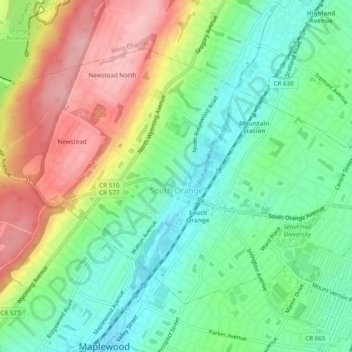
Name: South Orange topographic map, elevation, terrain.
Location: South Orange, Essex County, New Jersey, 07079, United States (40.73567 -74.28318 40.76230 -74.23470)
Average elevation: 94 m
Minimum elevation: 35 m
Maximum elevation: 184 m
Make a donation
Other topographic maps
Click on a map to view its topography, its elevation and its terrain.
Rahway River West Branch
United States > New Jersey > Essex County > Short Hills
Average elevation: 73 m
Make a donation
Make a donation
Make a donation
Make a donation
Make a donation
Saint Cloud
United States > New Jersey > Essex County > West Orange > Saint Cloud
Average elevation: 141 m
Make a donation