
Thank you for supporting this site ❤️
Make a donation
Make a donation
Calarcá topographic map
Click on the map to display elevation.
Thank you for supporting this site ❤️
Make a donation
Make a donation
Calarcá
The municipality has an area of 219.23 km2. Urban area is 2.44 km2. Rural area is 216.79 km2. It varies in altitude between 1000 m above sea level at the confluence of the Quindío y Barragán rivers to 3667 m above sea level in the El Campanario highland area.
Thank you for supporting this site ❤️
Make a donation
Make a donation
About this map
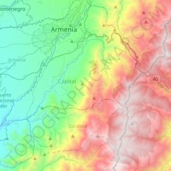
Name: Calarcá topographic map, elevation, terrain.
Location: Calarcá, Capital, Quindío, RAP Eje Cafetero, 632001, Colombia (4.33721 -75.80559 4.57137 -75.55585)
Average elevation: 2,149 m
Minimum elevation: 1,078 m
Maximum elevation: 3,726 m
Thank you for supporting this site ❤️
Make a donation
Make a donation
Other topographic maps
Click on a map to view its topography, its elevation and its terrain.