
Thank you for supporting this site ❤️
Make a donation
Make a donation
Além topographic map
Click on the map to display elevation.
Thank you for supporting this site ❤️
Make a donation
Make a donation
About this map
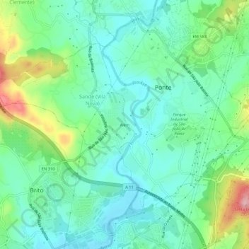
Name: Além topographic map, elevation, terrain.
Location: Além, Sande (Vila Nova), Guimarães, Braga, 4805-273, Portugal (41.44526 -8.36667 41.48526 -8.32667)
Average elevation: 144 m
Minimum elevation: 95 m
Maximum elevation: 274 m
Thank you for supporting this site ❤️
Make a donation
Make a donation