
Make a donation
Gdańsk topographic map
Click on the map to display elevation.
Make a donation
About this map
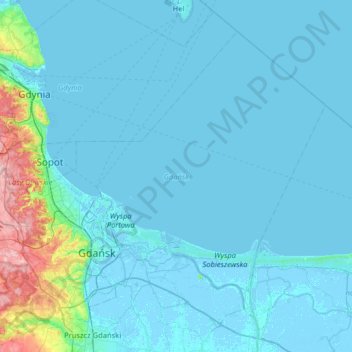
Name: Gdańsk topographic map, elevation, terrain.
Location: Gdańsk, Pomeranian Voivodeship, Poland (54.27492 18.42950 54.58273 19.07030)
Average elevation: 13 m
Minimum elevation: -5 m
Maximum elevation: 168 m
Make a donation
Other topographic maps
Click on a map to view its topography, its elevation and its terrain.
Jezioro Żarnowieckie
Poland > Pomeranian Voivodeship > Wejherowo County > Czymanowo
Average elevation: 37 m
Make a donation
Make a donation
Make a donation
Make a donation
Wieżyca
Poland > Pomeranian Voivodeship > Kartuzy County > Kolano
Wieżyca (Kashubian Wieżëca, German Turmberg) is a hill located in northern Poland, in the historical region of Kashubia, some 40 kilometers southwest of Gdańsk. With elevation of 329 metres above sea level, it is the highest peak of central and northern Poland. Its top is covered by a forest, and the hill…
Average elevation: 247 m
Make a donation