
Thank you for supporting this site ❤️
Make a donation
Make a donation
Guadix topographic map
Click on the map to display elevation.
Thank you for supporting this site ❤️
Make a donation
Make a donation
Guadix
The city lies at an altitude of 913 metres, in the centre of the Hoya of Guadix, a high plain at the northern foothills of the Sierra Nevada. It is located on the Linares Baeza–Almería railway. The city was built in the vicinity of gullies and badlands.
Thank you for supporting this site ❤️
Make a donation
Make a donation
About this map
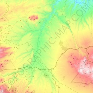
Name: Guadix topographic map, elevation, terrain.
Location: Guadix, Comarca de Guadix, Granada, Andalusia, Spain (37.23862 -3.26153 37.56132 -2.93718)
Average elevation: 1,043 m
Minimum elevation: 555 m
Maximum elevation: 1,763 m
Thank you for supporting this site ❤️
Make a donation
Make a donation
Other topographic maps
Click on a map to view its topography, its elevation and its terrain.
Puero de Jeres
Spain > Andalusia > Comarca de Guadix > Jérez del Marquesado
Average elevation: 2,671 m
Thank you for supporting this site ❤️
Make a donation
Make a donation