
Make a donation
Poreč topographic map
Click on the map to display elevation.
Make a donation
About this map
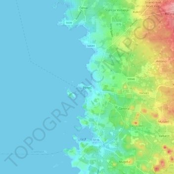
Name: Poreč topographic map, elevation, terrain.
Location: Poreč, Grad Poreč, Istria County, 52441, Croatia (45.18738 13.55569 45.26738 13.63569)
Average elevation: 25 m
Minimum elevation: -4 m
Maximum elevation: 127 m
Make a donation
Other topographic maps
Click on a map to view its topography, its elevation and its terrain.
Grad Rovinj
Since records began in 1984, the highest temperature recorded at the Sveti Ivan na pučini weather station at an elevation of 8 metres (26 ft) was 34.2 °C (93.6 °F), on 5 August 2017. The coldest temperature was −6.5 °C (20.3 °F), on 29 December 1996.
Average elevation: 24 m
Make a donation
Make a donation
Grad Pazin
Since records began in 1961, the highest temperature recorded at the local weather station at an elevation of 297 metres (974 ft) was 39.5 °C (103.1 °F), on 3 August 2017. The coldest temperature was −18.7 °C (−1.7 °F), on 8 January 1985.
Average elevation: 311 m
Make a donation
Make a donation
Make a donation
Make a donation
Make a donation
Make a donation
Make a donation
Make a donation
Make a donation