
Make a donation
Ribérac topographic map
Click on the map to display elevation.
Make a donation
Ribérac
Ribérac is on the left bank of the Dronne. To the north, the soil in the Dronne valley is covered with alluvium, while the heights are made up of Cretaceous limestones. Its minimum altitude, 54 meters, is located in the extreme north-west of the town, where a small arm of the Dronne leaves the town.
Make a donation
About this map
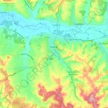
Name: Ribérac topographic map, elevation, terrain.
Average elevation: 107 m
Minimum elevation: 53 m
Maximum elevation: 198 m
Make a donation
Other topographic maps
Click on a map to view its topography, its elevation and its terrain.
Les Garrières
France > Nouvelle-Aquitaine > Dordogne > Saint-Saud-Lacoussière
Average elevation: 293 m
Make a donation
Make a donation
Le Clau du Bois
France > Nouvelle-Aquitaine > Dordogne > Saint-Romain-et-Saint-Clément
Average elevation: 221 m
Make a donation
La Croix de Ruchal
France > Nouvelle-Aquitaine > Dordogne > Rouffignac-Saint-Cernin-de-Reilhac
Average elevation: 239 m
Make a donation
Make a donation
Château de Castelnaud-la-Chapelle
France > Nouvelle-Aquitaine > Dordogne > Castelnaud-la-Chapelle > Castelnaud
Average elevation: 146 m
Make a donation