
Thank you for supporting this site ❤️
Make a donation
Make a donation
Oelde topographic map
Click on the map to display elevation.
Thank you for supporting this site ❤️
Make a donation
Make a donation
About this map
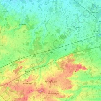
Name: Oelde topographic map, elevation, terrain.
Location: Oelde, Kreis Warendorf, North Rhine-Westphalia, 59302, Germany (51.75810 8.08180 51.89974 8.25989)
Average elevation: 100 m
Minimum elevation: 63 m
Maximum elevation: 174 m
Thank you for supporting this site ❤️
Make a donation
Make a donation
Other topographic maps
Click on a map to view its topography, its elevation and its terrain.