
Thank you for supporting this site ❤️
Make a donation
Make a donation
Svärdsjö topographic map
Click on the map to display elevation.
Thank you for supporting this site ❤️
Make a donation
Make a donation
About this map
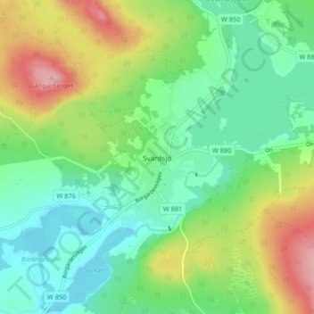
Name: Svärdsjö topographic map, elevation, terrain.
Location: Svärdsjö, Falu kommun, Dalarnas län, 790 25, Zweden (60.72230 15.88385 60.76230 15.92385)
Average elevation: 159 m
Minimum elevation: 114 m
Maximum elevation: 245 m
Thank you for supporting this site ❤️
Make a donation
Make a donation
Other topographic maps
Click on a map to view its topography, its elevation and its terrain.