
Make a donation
Valencian Community topographic map
Click on the map to display elevation.
Make a donation
Valencian Community
The warm-summer Mediterranean climate (Köppen Csb), humid subtropical climate (Köppen Cfa), oceanic climate (Köppen Cfb) and the desertic climate (Köppen BWh) are also found in the Valencian Community. The Csb climate is more common and is found in inland, high altitude areas (generally starting above 1,000 metres (3,300 ft)) across the 3 provinces of the Valencian Community, especially in the interior of Castellón but also in El Rincón de Ademuz and the north of Los Serranos comarcas in the province of Valencia. In the province of Alicante this climate is only found in the highest altitudes of Serra de Mariola and Sierra de Aitana. Both Cfa and Cfb climates can be only found in the interior of the province of Castellón, with marginal presence in the Valencian province, only in the Rincón de Ademuz comarca. The presence of the desertic climates (BWh) is marginal to scarcely populated areas south of Elche.
Make a donation
About this map
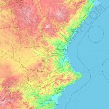
Name: Valencian Community topographic map, elevation, terrain.
Location: Valencian Community, Spain (37.84384 -1.52894 40.78863 0.69032)
Average elevation: 550 m
Minimum elevation: -5 m
Maximum elevation: 2,315 m
Make a donation
Other topographic maps
Click on a map to view its topography, its elevation and its terrain.
Make a donation
Make a donation
Make a donation
Make a donation