
Thank you for supporting this site ❤️
Make a donation
Make a donation
Juchitlán topographic map
Click on the map to display elevation.
Thank you for supporting this site ❤️
Make a donation
Make a donation
About this map
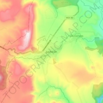
Name: Juchitlán topographic map, elevation, terrain.
Location: Juchitlán, Región Sierra de Amula, Jalisco, 48600, México (20.04406 -104.13641 20.12406 -104.05641)
Average elevation: 1,323 m
Minimum elevation: 987 m
Maximum elevation: 1,649 m
Thank you for supporting this site ❤️
Make a donation
Make a donation
Other topographic maps
Click on a map to view its topography, its elevation and its terrain.