
Make a donation
Bekasi topographic map
Click on the map to display elevation.
Make a donation
Bekasi
The City of Bekasi is a part of the Bekasi river basin, located in the downstream area of the basin with slopes ranging from 0 to 2% and elevations between 11 meters to 81 meters above sea level. The city of Bekasi is part of the Bekasi river basin and is located in the downstream area of the basin, with a slope ranging from 0 to 2% and elevations between 11 meters to 81 meters above sea level. This topographical condition leads to frequent flooding in many areas of Bekasi, especially during the rainy season, such as in the districts of Jatiasih, East Bekasi, Rawalumbu, South Bekasi, West Bekasi, and Pondok Melati.
Make a donation
About this map
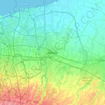
Name: Bekasi topographic map, elevation, terrain.
Location: Bekasi, West Java, Java, 17143, Indonesia (-6.39499 106.83454 -6.07499 107.15454)
Average elevation: 23 m
Minimum elevation: -5 m
Maximum elevation: 93 m
Make a donation
Other topographic maps
Click on a map to view its topography, its elevation and its terrain.
Make a donation
Make a donation
Make a donation
Make a donation
Make a donation
Make a donation
Make a donation
Make a donation
Bogor
The city is situated in the western part of Java island, about 53 km south of the metropolis of Jakarta and 85 km northwest of the city of Bandung, the administrative center of West Java Province. Bogor spreads over a basin near the volcanoes of Salak (which peaks at about 12 km south) and Mount Gede (whose…
Average elevation: 310 m
Make a donation
Make a donation
Cisarua
The district is known for its mild climate, tea fields, and extensive views, being located at a rather high altitude. Near the district is a mountain pass known for its villas and hostels, as well as a well-known "heritage" hotel known as the "Puncak Pass", built in 1928.
Average elevation: 1,270 m
Make a donation
Tasikmalaya
The city is located in the mountainous Priangan region of Java at an elevation of 351 metres (1,151 feet).
Average elevation: 367 m
Make a donation
Make a donation
DUSUN IV DESA MUKAPAYUNG KEC. CILILIN KAB. BANDUNG BARAT
Indonesia > West Java > West Bandung
Average elevation: 918 m
Make a donation
Make a donation
Make a donation
Cisarua
The district is known for its mild climate, tea fields, and extensive views, being located at a rather high altitude. Near the district is a mountain pass known for its villas and hostels, as well as a well-known "heritage" hotel known as the "Puncak Pass", built in 1928.
Average elevation: 1,270 m
Make a donation
Make a donation
Make a donation
Make a donation
Bekasi
The City of Bekasi is a part of the Bekasi river basin, located in the downstream area of the basin with slopes ranging from 0 to 2% and elevations between 11 meters to 81 meters above sea level. This topographical condition leads to frequent flooding in many areas of Bekasi, especially during the rainy…
Average elevation: 32 m
Make a donation
Make a donation
Bandung City
Bandung is the capital city of the West Java province of Indonesia. Located on the island of Java, the city is the third largest city in Indonesia and Greater Bandung (Bandung Basin Metropolitan Area / BBMA) is the country's second-largest and second most populous metropolitan area, with over 11 million…
Average elevation: 826 m
Kolam Retensi Cieunteung
Indonesia > West Java > Kabupaten Bandung > Baleendah > Citeureup
Average elevation: 663 m
Make a donation
Make a donation
Make a donation