
Make a donation
West Nusa Tenggara topographic map
Click on the map to display elevation.
Make a donation
West Nusa Tenggara
Selong (the capital of East Lombok Regency) is a city that has the highest altitude, which is 148 m above sea level, while the lowest Raba at 13 m above sea level. Of the seven mountains on the island of Lombok, Mount Rinjani is the highest mountain with an altitude of 3,775 m, while Mount Tambora on Sumbawa is the highest mountain with an altitude of 2,851 m.
Make a donation
About this map
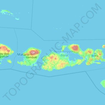
Name: West Nusa Tenggara topographic map, elevation, terrain.
Location: West Nusa Tenggara, Lesser Sunda Islands, Indonesia (-9.30984 115.57001 -7.51202 119.48874)
Average elevation: 45 m
Minimum elevation: 0 m
Maximum elevation: 3,330 m
Make a donation
Other topographic maps
Click on a map to view its topography, its elevation and its terrain.
Make a donation
Make a donation
Make a donation
Make a donation
Make a donation
Alun-Alun Ambarawa
Indonesia > Central Java > Kabupaten Semarang > Tambakboyo > Katang
Average elevation: 499 m
Make a donation
Make a donation
Make a donation
Make a donation
Make a donation
Make a donation
Make a donation
Make a donation
Make a donation
Make a donation
Make a donation
Make a donation
Make a donation
Make a donation
Make a donation
Mount Galunggung
One plane—British Airways Flight 009, carrying 248 passengers and 15 crew traveling from Kuala Lumpur, Malaysia, to Perth, Australia, on June 24, 1982—accidentally entered the ash cloud at night, about 150 km (93 mi; 81 nmi) downwind of the volcano. All four engines failed due to the build-up of volcanic…
Average elevation: 1,286 m
Make a donation
Make a donation
Make a donation
Make a donation
Make a donation